Saturday, October 29, 2011

Hampton River to Norfolk

On Wednesday we decided to move on from the Hampton River in Hampton to the Waterside Marina in downtown Norfolk.  Exiting a dock is not quite as harrowing as entering but it does make us anxious.  The skipper who fended us off the previous afternoon stood by with an extra fender in his hands ready to drop it between us at any point that we might make contact.  Again the Hampton Piers staff was extraordinarily helpful in handling our lines and pushing us off the dock.  Our exit was smooth despite the fact that our propeller tends to walk our stern to the left and the current was pulling us to the left.  Once out of the river we encountered winds gusting to 39 knots and 3 foot waves in the harbor.  The boat was quickly covered with salt spray. Every once in a while we would get a little spray in our faces.  The boat hobby horsed and slowed down to 2 knots against the waves, wind, and current but most of the time we could make about 4 knots.  We dodged a couple of barges and one very large ship heading in the opposite direction.  It took us 3 hours to cover the 12 mile run.

As we were trying to orient ourselves for our approach to Waterside Marina we got a powerful reminder of the need to keep a careful watch in all directions.  As we strained to see the entrance to the marina a tug and small barge seemed to materialize out of nowhere.  At less than 100 feet we were only a few seconds from a collision when Maryanne yelled: "Turn right, turn right!"  I spun the wheel to the right and revved up the engine.  The barge and tug were very small, gray and blended well with the background.  I was surprised that the tug captain had not sounded his horn because we were literally seconds away from a collision.  I also felt incredibly stupid.  These are the kind of mistakes that you just can't make.  A few seconds of inattention can have a horrible outcome.

Still shaken, I made my way into the marina and made a poor entry into our berth.  With a line fixed to a cleat amidships and Maryanne giving a little forward power from the helm the two Waterside dockhands were able to muscle Symphony around the corner of the dock into her berth.  Our entry was far from perfect but the help we had was excellent.  Phew!
Mermaids are everywhere in Norfolk.
This one is at the Waterside Marina
One of the ships we avoided on the way in.
They are really BIG!


These two mermaids were at Half Moone Cruise
and Celebration Center next to Nauticus.  The Center is
billed as a "gateway to Bermuda and the Bahamas."  Hmm...
I wonder if that's how we should have done it?

Princess Azelea at Nauticus

We found this mermaid
headed skyward


USS Wisconsin at Nauticus, Norfolk, VA

Tall ship sunset cruise from Waterside Marina


Figurehead of the tall ship.
We didn't spend a lot of time sight seeing but we did walk by the USS Wisconsin and spent some time in the Douglas MacArthur Memorial.  Maryanne was looking for any mention of her father's group: Edson's Raiders but didn't find any.  With bad weather forecast within the next few days we decided we would head to the ICW and the Dismal Swamp Canal the next day.

View of the food court & Norfolk Skyline from our boat.

Thursday, October 27, 2011

Deltaville to Hampton River

Once again Maryanne suggested that we ignore the small craft advisories and head south to Norfolk.  We were able to do a little sailing and a lot of motorsailing - 7 hours in total.  The number of different ships, barges, tugs, pleasure craft and military craft was daunting at the entrance.  We dodged a couple of tugs pushing gravel and one good sized ship.  It was strange to take a channel that brought us next to a highway bridge that descended into a tunnel underneath us.  We followed what seemed to be a crooked narrow channel into Hampton River.  Coming into docks is always a challenge for us.  The Hampton Public Piers was no exception.  The staff was incredibly helpful with the docking but we did manage to drift a little to starboard - perilously close to another sailboat in the berth next to us.  Fortunately, the skipper was alert and not only pushed us off but extended his body almost completely over the water to hold us in place while we awkwardly tied a line off our stern to a piling.  Meanwhile, two workers from the Public Piers handled our bow line and a spring line amidships.  The dockmaster made an excellent recommendation for dinner - the Conch 'n Bucket.  Outstanding jambalaya for me and vegetarian fare for Maryanne.

This is one of the guys we dodged on our way in to Norfolk


Our berth at Hampton Pubic Peers.  They provided the stairs for us
despite the fact that Maryanne would prefer to swing ashore on
a halyard Tarzan style.


This lovely Hinckley arrived in Hampton 3 days out of Newport, RI.
(It took us 3 weeks from LI.)  The delivery crew washed and polished
every inch of the boat for the new owner who was taking delivery in Hampton.

Reedville to Deltaville

This guy is the real deal - a Chesapeake Bay Crabber.
We agreed to let him jump ahead of us to buy $200 worth
of diesel fuel.  I have no idea how he can make a living at this.


I ran by this marina in Deltaville.  Love the traditional
Chesapeake Bay lighthouse. 
(Monday) Reedville to Deltaville was an OK 4 hour run under motor with a little sailing as we turned west out of the Chesapeake.  The staff at the Deltaville Marina was friendly and helpful.  We anchored out but for a fee ($11 per person) we got access to their facilities including lounge, laundry, and a car for one hour.  The car was the best part of the deal.  We were able to get to West Marine, a grocery store, the liquor store, and the new headquarters of Dozier  Waterway Guides.  We decided to splurge on 2012 guides to the ICW and the Bahamas to replace our 2008 guides which had a few listings that no longer exist.  It was fun meeting some of the staff.  The worst part of our deal with the Deltaville Marina was the laundry.  The wait was long, the one drier was small and didn’t get everything dry.  Maryanne got the worst of the deal – doing the laundry while I took a 4 mile run.  


Tuesday, October 25, 2011

Reedville

This is a small part of the Reedville fishing fleet.
On Sunday it became clear that Deltaville was well beyond the distance we could make during daylight ours so we headed into Cockrell Creek next to Reedville.  The Cruising Guide said that the fish rendering plant at Reedville could make our anchorage malodorous.  After some debate we chose Cockrell Creek over some other choices that were either a little less protected (Fishing Bay) and some that were possibly more scenic.  We were happy with our choice.  There was definitely a strong odor of fish as we passed the fish rendering plant by a huge fleet of large fishing vessels but the anchorage we chose was beautiful and there was no odor of fish.

Gillean, a Valiant 42, singlehanded by Douglas was the only
other boat in our Reedville anchorage.

The water was mirror smooth and the scenery postcard
picture perfect on our way out of our anchorage.

The Solomons

We planned a long sail today (Saturday) from the Solomons to Deltaville.  Because we have been delayed by weather we were feeling pressure to move south.  We were also feeling a little cabin fever.  We love our boat but there are times when you need a little space from the people and the things you love.  As we were preparing to go to sleep we discovered an email from Dennis and Carolyn, members of the Caliber Cruising Club whom we had met several years ago at a Club function in Annapolis.  They asked if we would like to stay at a guest slip in their condo community for a very small fee.  If we had been thinking clearly we would have jumped at the chance.  Instead, we sent them an email explaining that we were under pressure to move south but we looked forward to seeing them further south.  When we woke up it seemed that it might be a good idea to do some laundry, buy some produce at the supermarket, and learn a little bit about the cruising area from people with a lot more experience than us.  We sent off an email expressing interest in staying on the dock and hoped that Dennis would be checking his email this morning at the same time he sent the email the previous morning – otherwise we would take off for Deltaville a little bit later than we had intended.  We got a phone call within 15 minutes of sending the email.  Dennis & Carolyn were helpful beyond words.  The dock space was convenient –  to land at – especially with Dennis handling our lines for us – and it was convenient to the local grocery store.  Dennis and Carolyn had a wealth of information for us that will make our cruise much easier.  I managed to get in a 4.5 mile run.  Between that and our walk to the store our cabin fever was cured.  And on top of this about .75 miles from our dock CVS had the Sunday Times available at 8 am the next morning.  We had hoped to leave earlier but the Sunday Times is an imperative.   At 7:40 I began a slow jog to CVS.  A familiar voice asked if I’d like a lift to the front gate.  Dennis and Carolyn happened to be driving out and took me to the front gate and beyond to CVS.  I was the first customer in the door & left quickly with the Post & the Times making it back to the boat in 8 minutes.  Yes, I clocked it.  There was one small problem.  As I was taking pre-departure photos of the mist on the water, the mist suddenly thickened into impenetrable fog.  Our hopes of making it to Deltaville before dark began to fade.

The mist thickens to fog.  Exactly what you don't want
to see when you want to make an early start.

I was assured that pirates would not be a problem on this cruise.
These are locals collecting for the Wounded Warriors project
in the Solomons.

Friday, October 21, 2011

St. Michaels to the Solomons

Today’s NOAA forecast included a small craft advisory for west winds gusting to 25 knots.  I figured OK one more day in St. Michaels.  No need to sail in uncomfortable conditions, especially since Maryanne doesn’t seem to enjoy going out in heavy weather.  Surprise, surprise – Maryanne suggested we go down the Choptank river and if the conditions were too rough we would put into the little Choptank only 7 miles further south.  I was not ready for this.  I prepared the boat as quickly as I could but we still got off to a late start.  About 30 minutes out of the creek with the sails pulling well I looked at the dinghy realizing that I had forgotten to put an extra line on it to secure it.  Oops.  I didn’t just forget the extra line – I forgot to take the engine off the dinghy.  We had to roll up all the sails and drift while I locked the dinghy to the stern and removed the engine.  Broad Creek was well protected so the job was more aggravating than difficult.  Once again Maryanne and I discussed that check list that we know we need to institute. 
While the winds did gust once or twice to 25, most of the time we had perfect conditions, making almost 8 knots (2 more than we usually cruise at) for an hour.  We decided to go all the way to the Solomons on the Patuxent River.  Today’s journey took 6.5 hours with about 2 hours spent under sail, the rest – motorsailing.  We are 63 miles from Washington, D.C.  and maybe 80 from Norfolk, VA.

Thursday, October 20, 2011

San Domingo Creek

Despite the good protection it offers San Domingo Creek was not a good place to sleep last night with winds kicking up over 30 knots.  The rigging was singing loudly as the boat swung on its anchor from side to side heeling as it moved.  Down below in a boat the sounds above all seem to be magnified.  It is hard to believe with all the noise you hear below that everything will be OK topside.  I had to have faith in the anchor otherwise sleep would have been more than difficult - it would have been impossible.  We made it through the night.  Despite the heavy wind we took our tandem ashore for a ride.  In the warmth of our enclosed cockpit we underestimated the need for warm clothing.  We were freezing as we assembled the tandem almost a half mile from the boat.  Climbing ashore out of the dinghy was a little easier than usual with high tide about 2 feet above normal.  The strong southwest winds had been piling water up the Chesapeake all night.  This made the bulkhead wall almost even with the dinghy.  The lawn just over the wall very wet.  In town we discovered that the high tide had cut off some of our approaches to the Maritime Museum.
This gives you an idea of some issues
caused by an extra high tide.

We saw that there are some 2 acre plots still for sale around the creek - a steal at only $1.7 million with a new home.  Our tandem ride took us down country roads past farms and along the creek.  It is surprising to us how rural this area is outside of town.  We had a wet cold ride to the boat with the tandem in the dinghy.  The warmth of our enclosed cockpit never felt so good!

Wednesday, October 19, 2011

A rainy day in St. Michaels

Today was a rainy day but Maryanne and I managed to get ashore during some breaks in the showers.

I have been taking pictures on my runs.  Here are a few of the things that have caught my eye today.
St. Michaels - Who could resist fun things?

St. Michaels seem to take
Halloween seriously - figures
like this one are on almost every
telephone pole

A warm welcoming porch in St. Michaels
This covered bridge is part of a nature trail - and part of
my 3 mile run today.

On a break  from grading papers Maryanne spotted this
sign just across the bridge next to a horse farm.

Tuesday, October 18, 2011

Annapolis to St. Michaels

This sea of masts gives you a little idea of
how many sailboats are packed into Back Creek
Back Creek in Annapolis was a frustrating place to try to anchor.  The cruising guides warn about not blocking access to the docks and not anchoring in any city mooring areas.  That leaves precious little room for an anchor - especially one like ours with only 20 feet of chain.  Most boats we saw used all chain.  One cruiser told us he had been anchored in Back Creek for 4 days and had to re-anchor 4 times.  Reluctantly, we parted with $30  for a city mooring.  Annapolis has more beautiful sailboats per square foot than any other port we have ever seen.

We took off too late in the afternoon for a hair-raising tandem ride on a very busy 4 lane  road to the Giant Supermarket.  Waiting behind a bus at a red light in a turn lane for 2 lanes of traffic was unnerving - but we survived.  We managed to fit quite a few groceries into our panniers with a dozen eggs bungeed on top of our trunk rack.  Our real challenge was getting the bike folded up and carrying it down a ladder to our dinghy that was no longer at the bottom  of the ladder.  The dinghy had been displaced by other dinghys.  Luckily one of the owners came by and not only moved his dinghy but he waited around to receive the bike as I lowered it to him.  Maryanne is training to be an acrobat.  She climbed down the ladder and almost jumped into the dinghy.

We debated where to spend the next several days of bad weather. To the Solomons or to St. Michaels - that was the question.  We decided after hearing rave reviews of St. Michaels that we would head there.  After we started we began debating.  Do we go the direct route by way of the Miles River to the harbor in St. Michaels or do we go the long way and take the back door through a canal in Tilghman Island and travel through a labyrinth of creeks off the Choptank River.  The cruising guides told us that anchoring room in St. Michaels was limited and that the holding isn't good.  Further it was explained that if you drifted across the channel on your anchor you would get a ticket from the police.  The advantage of the creek was - no tickets and good protection from bad weather.  NOAA  which has been reliably inaccurate in its forecast of winds this week has predicted possible gale warnings within the next couple days.  The creek made sense not only for the protection but it will offer us a more direct route south when we decide to finally go.  I did push the limits of the creek as far as I could.  I went to the last spot on the creek that was marked at 7 feet.  My depth finder read 4 feet.   I'm guessing that the depth finder is off by about 2 feet so that should give me about 6 inches of clearance over the bottom.  I hope that's enough.
Which side of this bridge would you like to fit
your 62 foot mast under?  I wanted to push the concrete wall
further to the left!  This is the "back door" through Tilghman Island
(Setting for Michner's Cheasapeake

We managed a quick walk into town to see where we might want go when the forecast rain lets up.
This is one of the many Chesapeake Bay Skipjacks that call
Tilghman Island home.

Monday, October 17, 2011

Sasafrass River to Annapolis by way of Worton Creek

Our plan to sail from the Sassafras River about 30 or so miles to Annapolis was changed by 25 knots of wind on our nose.  We decided to go only about 6 miles to Worton Creek.  We were a little anxious about finding a place to anchor because the water is spread pretty thin throughout the creek.  We decided to top off our tanks at the Green Point Marina before anchoring.  After a longish (2 hour) wait we left a message for the Marina owner that we would be off riding our bike but would return in an hour.  Off we went down the scarcely traveled back road through the woods and past large open fields.  This area of the Eastern Shore is undeveloped and beautiful.

Having been told what car the marina owner drove - we were able to identify him heading back toward the Marina.  We turned around and met him about 10 minutes later.  We filled the tanks.  He said that right after we paid he was leaving and that we were welcome to spend the night on the dock.  OK!  All was good until the wind shifted at 3 am pushing the boat against the dock.  I awoke to the loud creaking of our rub rail rubbing against a piling.  I set up a fenderboard to protect us.  With a few adjustments of our lines on the pilings I was able to get back into bed.

The Chesapeake Bay Bridges
 we passed under them about 12:30
shortly before entering Back Creek
The next morning we finally headed toward Annapolis with a fair wind.  We are currently sitting on a city mooring in Back Creek.  With rough weather forecast later in the week we plan to head to St. Michaels on the Eastern Shore tomorrow.

Saturday, October 15, 2011

Havre de Grace to the Sassafras River

We became impatient to make progress south today.    It makes me think of how I feel when I'm waiting a long time at an intersection to make a turn.  After a while my idea of what a safe distance is begins to change.  I think I need less space to turn with ongoing traffic.  Today there were small craft warnings to be posted late morning.  We left Havre de Grace at about 9 a.m. and motored up the very narrow 5 mile channel to get into position to cross the Chesapeake.  I figured how bad could a few miles across the Chesapeake be?  It was slow and uncomfortable with our speed slowing to 2 knots when we hit a big wave and increasing to 4 knots in lulls between big waves.  The highest gust we saw on the anemometer was 41 knots.  I will try to post a short video that doesn't quite do justice to the motion but will give you some idea of what it was like.  Right now I'm sitting in the dark cockpit enjoying the stars just off Turner Creek on the Sassafras River.  We're both glad that we chose a destination that was near by.  Tomorrow we will wait until the wind is much better.

Friday, October 14, 2011

Thunderstorms in Havre de Grace

Today was a day for thunderstorms in Havre de Grace.  Nothing really big but torrential rain for a few minutes a couple of times.  One of the cloud bursts took place during my 3 mile run on a trail up the Susquehanna.  I had to walk part of the trail because the river had recently covered the trail.  Parts of the trail had turned to muck.  The rising river creates some serious problems from time to time.  The staff at Tidewater said that Hurricane Irene had put their store 2-3 feet underwater.  They were up to their knees moving stock out of the store at the end of the dock and back to their flood proof store on Market St.

Living aboard has changed Maryanne.  She seems to be enjoying the accomplishment of cooking in a challenging environment.  She is cooking meal after meal.  Not just simple stuff - really delicious meals.  Even though she is a vegetarian I get pork chops with apple raisin stuffing.  Today she baked lasagna with sausages at one end for me - hearts of artichokes on her end.  Also today she baked brownies.
Maryanne at work in our less-than-spacious galley

We brought some brownies and her special cheese spread to share with Norm and Jan aboard S/V Bandersnatch.  Norm designed and built the 63' ferrocement boat himself.  The boat seemed enormous to us with its 18' beam and large cabin windows.  The tour of the engine room was an overwhelming experience.  Jan is talented jewelry designer who actually creates jewelry in her workshop aboard their floating home.  We enjoyed our visit with them.

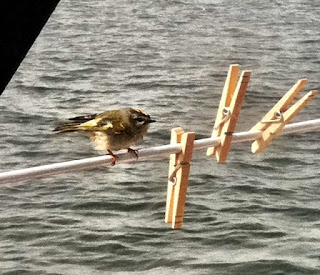
This poor little guy joined us in the middle of Delaware Bay.  The Bay is wide enough that you can't see land in any direction.  I think he was pretty tired.  We were motoring along when we heard a metallic sound.  Maryanne thought is was related to our engine or autopilot.  It turned out to be this tiny bird.  Is it a goldfinch?  Compare his size to the clothespins next to him.

Thursday, October 13, 2011

Foggy Day in Havre de Grace

The weather has not been cooperating with us.  Yesterday and last night's rains have been followed by drizzle and fog today.  Tomorrow will be rainy also.  Maryanne is practicing with her "Pro Chopper Plus," a manual Cuisinart   She is whipping up a cheese spread with hard boiled eggs, mayo, grated cheddar cheese, grated pepper, onion, black olives, and tabasco.  The bad news is it's hard to stop eating once you dig into one of her creations.

We decided to give up our $30 mooring tonight to anchor for free.  The only cost - unsettled sleep.   A neighboring cruiser told us it is not good holding ground here.  He had some trouble setting his anchor.  Our Manson Supreme anchor seems set OK but it's stretched out under our boat.  There are changing currents here on the Susquehanna River.  I hope the anchor holds.  Amtrak will keep me on my toes -- it thunders across the bridge near us on a regular basis.

Wednesday, October 12, 2011

Havre de Grace

Havre de Grace has been an excellent spot to wait out bad weather.  It was raining this morning and pouring buckets this evening.  Our $30 mooring at the Tidewater Marina gave us access to their courtesy van which we used to go to ShopRite, Home Depot, and the local "Fluff & Fold" laundromat.  We should have taken a picture of all the goodies we loaded the dinghy with.  We barely fit.  I hoped that I had put enough gas in the engine because it was blowing hard, the water was choppy and the current was strong. Even if I could reach the oars, I couldn't row fast enough to reach our nearby boat.  We made it without a problem but the dinghy was pretty bouncey on the stern of Symphony.  We have a unique locking device made from Weaver Brackets that locks the side of our dinghy to the back of our boat.  It means that Maryanne can stand on a relatively stable platform - the side of the dinghy - as she climbs up the transom.  Our set up on the transom was conceived and crafted by Jay, the owner of Merri-Mar Yacht Basin, Inc.  We have a number of modifications to our boat that make it much more comfortable thanks to Jay, his son, and the staff at Merri-Mar.

I have been very frustrated with the poor reception of my FM radio.  The trip to Radio Shack gave me the last items I needed to connect the radio to the antenna splitter that is used for my VHF and AIS.  Now the antenna on the top of the mast is my FM antenna as long as I am not using my AIS or VHF.  We can once again enjoy NPR at anchor.

Tuesday, October 11, 2011

3 States in one day

We were feeling a little chill on the Delaware River but were warmed
by the sight of this nuclear plant


Our neighbor in Havre-de-Grace
Nice spinnaker headed south
past us in the narrow channel
into Havre-de-Grace
So we escaped the Cohansey river just before dawn and just before the flies were up for the day.  We had the good fortune to follow out two other sailboats.  They led me through deeper water than I had traveled into the river last night.  We were able to keep up with the other boats by motor-sailing up the Delaware.  For some reason we can't seem to motor as fast as any other boat our size.  The river was not exactly scenic as we approached the C&D canal.  The canal was a nice contrast with trees that were beginning to turn.  We were passed by a number of mega-yachts usually with homeports like West Palm Beach or Kingston.  We had an 8 hour day of motoring from NJ through Delaware to Havre-de-Grace, MD.  We had one heart-stopping moment motoring up a narrow channel a few miles south of Havre-de-Grace.  As the motor  ran smoothly - as smoothly as marine diesels run - we heard a loud (very loud) BOOM!  I thought the motor had blown up - but it was still running - then I was sure it was a big log we had run into.  Maryanne said no - she felt it in her chest.  OK - she was right again.  She read the cruising guide that mentioned that the Aberdeen Proving Ground was used for testing weapons and that occasionally there were explosions that could be heard across the bay.  Phew!  It was realllly loud!  We decided to take a mooring tonight with 25 knot winds - small craft warnings - and rain predicted for tomorrow.

Cape May to the Cohansey River

Cape May Light House
I hate getting up early but Monday morning we got up before dawn.  We knew we were facing a potentially 10-12 hour journey to the Cohansey River 25 miles up Delaware Bay.  We would be fighting an adverse current and a headwind with no possible alternative stops.   I had been apprehensive about taking a short cut through shoals to get around the cape rather than travel many miles out to the ship channel.  I had visions of Symphony heeled over as the keel dragged sideways across a shoal.  Cruising guides warned that the shoals were constantly shifting and that Eph shoal in particular was moving toward the beach.  Maryanne had the first shock of the day when she couldn't turn the wheel as I pulled up the anchor.  I forgot to tell her about the lock on the wheel.  My bad.  She was not happy.  Because the seas were almost flat and the wind was mild I decided to follow some waypoints that were given to me this summer by a more experienced cruiser.  If the depth finder read 10 feet or under I planned first to panic and then to make the fastest U turn that I could.  My course brought me right straight into the beach by the Cape May lighthouse.  My stomach tightened at one point when the depth finder went to 15 feet but before I could implement my panic mode the depth increased.  The path through the shoals wasn't all that bad.  The adverse current only slowed us by 1 - 1.5 knots.  Just beyond the cape I could see a ferry headed across our path.  The Twin Capes seemed to be bearing down on us at 3 times our speed.  The AIS showed us clearing the ferry but just to be safe I called the captain on the VHF.  I offered to change course.  The captain was very reassuring.  "Skipper, I have you .3 miles ahead of me and clearing me by .1 of a mile but it's your call."  I told him I would maintain my course.  "OK, have a nice day" was his response.  I am really getting to like AIS.  It gave him and me the data for making the decision about collision avoidance and it gave me his name so that I could call him.

After 10 hours we arrived at the Cohansey River.  I didn't quite panic when the depth finder read 4 feet even though our draft is 5'5".  I was concerned.  Eventually I found deeper water and entered the river.  The Cohansey river experience will not soon be forgotten.  Swarms of flies converged on us by the thousands.  My pants turned black from all the flies.  If I shook my legs they flew around me and landed back on them instantly.  I couldn't even shake them off.  They bit painfully.  We were miserable.  It seemed to take forever to get far enough into the river to anchor.  That anchor got set as fast as I could get it over the side.  Maryanne backed down on it and we tried to duck into the cabin as our relentless pursuers followed.  I discovered that the flies inside the boat were drawn to the porthole screens.  I could push out the bottom of the screens and get them to fly away.  I was a little obsessed with this task for a good hour.  Meanwhile after a long exhausting day Maryanne decided to undertake an equally difficult culinary task.  Dinner was apple raisin stuffed pork chops, quinoa, and stir fried vegetables and salad.  Mmmm... unreal!  Although we were exhausted we decided that it would be best to leave the river the next morning before the flies had enough light to fly.

Monday, October 10, 2011

More Cape May

This summer it became clear that one of the highest priorities for Maryanne - to be worked out by Wednesday - was a plan to be in a port on Sunday where the New York Times was available.  I took a jog past Cape May's beautiful Victorian homes and ended the 3 miler just short of the Acme supermarket.  My stomach dropped at the sight of the empty NY Times shelf.  I checked - indeed they were sold out, but the WaWa by the Lobster House might have them.  The clerk warned me that it wasn't within walking distance.  (Maryanne and I had just covered that distance and then some the day before.)  My 3 miler became a 4 miler.  I ran with an added sense of urgency hoping against hope that I would get there before the last Times sold out.  Success!  I returned with not only a Times but also a Washington Post.

Later that day we loaded our Bike Friday Two'sday Tandem bike onto our dinghy for a quick tour of the Victorian homes that Maryanne had not had a chance to see on foot the day before.  The bike always gets lots of comments: "You fit THAT on a SAILBOAT?!"  Cape May has quite a collection of Victorians - many more than Sea Cliff next our home port.

We returned a little late to the boat.  Maryanne quickly lifted the 9.9 hp Tohatsu onto the rail and I slowly lifted the dinghy with a halyard onto the foredeck.  One question haunted me.  Could I successfully navigate through the shifting shoals close to Cape May or should I choose the safer and hours longer route out to the the ship channel.  The dire descriptions of chop on the very shallow Delaware Bay with a current against me all day had me worried.  We planned to leave as soon as there was enough light on Monday morning.


Cape May

Maryanne aka Wonder Woman lowered our new 83 lb Tohatsu into the dinghy without breaking a sweat.  The little crane we have on the stern helped.  The engine purred on the first pull of the starter cord and carried us into town faster at idling speed than our 2 hp did at full speed.  Unfortunately, on our return to the dock our brand shiny new outboard coughed a little and died when I pushed in the choke.  The engine refused to start.  Fortunately, the skipper of another dinghy offered us a tow.  For one mile we endured the ignominy of being towed with our new engine.  We couldn't thank our French speaking Samaritans enough.  A little time with the engine manual helped me learn how to start the engine if it didn't start on the first 5 tries.


Friday, October 7, 2011

Day 4: Overnight from Great Kills to Cape May

We decided to travel in the company of another  boat overnight from Great Kills to Cape May.  We met the captain, Steve, by VHF when he hailed us in lower NY Harbor.  He had told us that he usually sails overnight to Cape May from the Great Kills area.  We met him in person in the harbor and worked out our timing for the next day's departure.  We kept in contact by VHF at regular intervals coordinating motoring and sailing for the first few hours until a good breeze developed by noon.  Occasionally, we slowed to 3 knots but eventually we were making hull speed - 6 knots which we were able to maintain  during most of the sail to Cape May.  It was so nice to feel our 25,000 pound boat pushing through the water with no engine thrumming below - not to mention that we didn't have to burn any of the diesel fuel we paid $4.59 per gallon for at Great Kills.  Our 46 gallon tank would remain almost full.  It was a little spooky sailing in the dark.  Several times I glanced a big bright light close ahead only to realize I was looking at the moon.  It was a very clear and well moonlit night.  At any given time we could see a dozen boats or so heading in the same direction as we were in the small hours of the morning.  With the AIS (Automatic Identification System) the guesswork was taken out of determining where a tug or ship was heading.  The AIS tells you immediately how close you can expect to pass on your present course and in how long.  The system works only with other boats who have it.  Over a certain size it is required equipment.  We noticed through AIS that a boat, Ananda, was passing across our bow.  We hailed them and had a pleasant conversation with the helmsman.  When we inquired about our AIS data he went below to look at it and reported it to us.  Our AIS transmitter is working well.  He then explained that the reason he was crossing our bow was to avoid a large rectangular area (about 5 miles long) on the chart that said "Research Area - Numerous Buoys."  We were headed straight into that area.  Decisions, decisions.  I told him that I thought the moonlight ahead of us was adequate for seeing buoys unless they were small like lobster pots.  He agreed and said that there had been much debate among his crew about whether or not to go through.  I opted to go for it.  I checked with our friend, Steve, who said he had seen a few small buoys but that he was already in the middle of the area.  He didn't know what the notation "Numerous Buoys" meant either.  We went through with no problem.  I didn't want to have to sail down wind and try to pull in the sails tightly, heeled over, trying to get back up wind after ducking under the buoy area.  Fortunately, it worked out.  

The wind came up later in the evening strong enough so that I had to consider shortening sail - but I was too tired and the wind was not too strong yet.  There is an old adage among sailors that when you think its time to reef it's already too late.  Fortunately, I lucked out - the wind did not build any further, but it did make me realize that out at sea when the conditions get rough you are stuck out there - you can't just go home and wait for better conditions.  Maryanne did a great job of making me comfortable in the cold cockpit with spaghetti & meat sauce, hot chocolate, and yes - even fresh baked brownies.  Delicious.  That, long johns, 5 layers of shirts and jackets, plus a complete cockpit enclosure made the night bearable.  Maryanne who was not super psyched about doing an overnight sail handled it well.  I was surprised when she suggested that we try it.  She gets a medal for bravery.

Atlantic city was visible from more than 20 miles away.  One building was covered with animated lights that flashed constantly changing animated images that could be seen 10 miles away.  Atlantic City is a garish sparkling grotesque sight from offshore.  In contrast the sky lit up with stars when the reddish moon sank into horizon at 3:50 a.m.  I was not as tired as I thought I would be after a night without sleep.  We arrived at Cape May just after sunrise and anchored by 8 am.  After launching the dinghy I fell into my bunk until 6 pm.  I guess I was tired.

Great Kills

Great Kills proved to be an excellent harbor for protection from northwest winds.  The wind was gusting to 30 knots as we approached under sail.  The harbor seems to be filled with moorings but there was enough room to anchor between the mooring field and a retaining wall near a launching ramp.  The launching ramp was the scene of intense police activity.  Several police cars, a rescue truck, 2 police boats and a couple of police trailers were on the scene.  With the binoculars we could see several policemen staring down into the bottom of a police inflatable.  Later a group of them seemed to be carrying something out of the boat and into a trailer.  We had the feeling something very bad had happened.

Later after most of the police had left I took a 2 mile jog out to Crookes Point and back.  I pushed myself a little because I had forgotten to bring an extra lock to lock up the dinghy.  I had to decide between locking the dinghy to the dock or locking the engine to the dinghy.  I opted for securing the motor - not the dinghy.  After the jog I took a little swim under Symphony to scrape off the keel cooler for our refrigerator.  The keel cooler is a plate attached outside the hull through which the refrigerant passes to cool.  The water in Great Kills is cold and not clean.  I couldn't see more than about 6 inches so I had to feel around under the boat to find the plate.  I was able to scrape most of the barnacles off.  It took me 3 dives to feel around for the paddle wheel for our speedometer on the shady side of the boat.  I freed it up and we now can get a reading of our speed through the water vs. our speed over the bottom.  Finally I scraped all the small barnacles that had attached themselves to our folding propeller.  October isn't the best month for swimming in Staten Island.  It took me a good half hour to get rid of the chills after my hot shower in the cockpit.  I hope I don't get sick from the pollution!

Wednesday, October 5, 2011

Day 2


Above: (starting from the bottom)  The Throgs Neck Bridge - our first bridge of the journey; lower Manhattan; a container ship in Brooklyn stacked all the way up to the tall bridge - no wonder these containers are found floating just at the surface of the sea all over the world;  And finally, the Verrazano bridge - that's one verrry big bridge.

We have had a different NY experience from City Island through Hells Gate, under the bridges of the the East River and finally sailing down lower NY Harbor to Great Kills Harbor in Staten Island.  No matter how many times you have done it there is something special about seeing Manhattan from your boat.  With the current at times we were doing double our usual 5 knot speed.  It was fun to see that we were keeping up with the rush hour traffic on the FDR.  A loud roaring sound puzzled us until we realized we were hearing cars, trucks, and trains on bridges over our heads.  The river was not very busy - in contrast to the lower harbor that was full of ferries, tugs, ships, and barges.  We were able to sail the lower harbor and finally dowsed our sails as the wind gusted to 30 knots just as we arrived at the entrance to Great Kills Harbor.  We are fueled up and contemplating an overnight sail in the company of another boat from Ontario, Canada.

Tuesday, October 4, 2011

First day - 2 whole hours

Finally we are under way. A little rough with 20+ knots on our nose to start but then an hour of nice sailing to City Island Harbor. We figure at this rate we'll be in Cape May in 2 weeks. We'll have to pick up the pace a little. At 8:30 pm I'm listening to the promised 25 kt gusts howling through our rigging. This may call for letting out a little more anchor line.