Wednesday, December 28, 2011

Fernandina Beach

Yesterday we planned as a lay day.  Good thing - because when we got up it was blowing stink and raining off and on.  I spent most of my time wiring in the Atlas ham transceiver that my friend David donated for our cruise.  It took me most of the day to snake the wires through the back of lockers, behind our microwave and through holes that were smaller than the wires I was trying to stuff through.  I had to study the back of our circuit breaker panel to try to remind myself where the wires went.  Where does the positive go?  Does the switch interrupt the positive side?  I figured it out.  Foolishly, I did all of this before even powering up the rig to see if it worked.  It did.  The reception was much better than I get from my Icom 710 Marine SSB but I could not get the microphone to work.  That will be my next project.

When the weather let up in the afternoon Maryanne & I took a cab to the local Publix to provision for the next few days.  We decided on one last dinner out at a local Mexican restaurant before we started dipping into our newly refreshed larder.

I liked the juxtaposition of the Christmas Tree
with the Palm Tree.  That may be one of Cortez's
Ships on the obelisk behind us.
As a resident of Nassau County I was amused to see a sign out in front of the Historic Nassau County Court House in Fernandina Beach.  I think I like this courthouse better than our own Nassau County Courthouse where I used to run a court project and bail fund for young people.


The next morning we had the pleasure of once again following our sister ship, Brilliant Star.  Her skipper made our navigation job much easier - especially since he has set up a spreadsheet showing where to be at what times to make the right tides.  There are some shallow spots where we don't want to be at low tide.  The  number of different cuts and rivers make calculating tidal current almost impossible.  We got to Jacksonville Beach early enough in the afternoon to take a little time ashore.
Beach Marina at Jacksonville Beach.  The bow of our boat is
barely visible at the far left behind a big powerboat.


This is the approach to the marina - typical of the ICW.  The beauty of the scene
 is not enhanced by the billboard advertising another marina

Monday, December 26, 2011

Duplin RIver to Brunswick to Fernandina Beach (FLORIDA!)

Strong (loud) winds, chop, and strong currents did not make for a good night's sleep on the Duplin River behind Blackbeard Island.  Once the anchor reset with a flood tide late at night I decided that would be a good time to try out our newest app on the iPhone: the DragQueen anchor alarm.  Bad idea.  The alarm on the drag queen sounds something like the sirens you hear in European movies.  Despite setting it for 150 feet of movement instead of the customary 100 feet, the alarm woke us from a sound sleep 3 times during the night.  I put out a lot of anchor line to give us the best holding possible - but with the tide and wind in opposition the boat wandered around in the blackness all night.  I will not be using the DragQueen on rivers with flood and ebb currents that change every six hours.

After a restless night we motored for several more hours on the ICW.  The ICW gets a little monotonous after a while.  You can't really relax because you are constantly searching for the next mark while trying hard not to run aground in narrow channels.  Some of the narrow channels are invisible sections dredged out of areas of water that can be a half mile wide.  If the marks are not close enough you can spend some anxious moments looking for them.  In wide sections of water it is hard to tell where the center is and more importantly where the channel is.  We did successfully negotiate Hell Gate with an almost full tide.  At low we would have been a foot short of what we needed to keep Symphony floating above the bottom.

We thought we would put in to the Frederica River to end our day on Christmas Day.  After reading  that the bottom can be hard and difficult to set your anchor in, we decided another sleepless night was not what we needed.  We called the Brunswick Landing Marina for a dock space but no one was home.  This was probably appropriate for Christmas Day - a day when another couple supposedly had trouble finding accommodations two thousand years ago.  We decided to head to Brunswick anyway, figuring that we could probably tie up to a fuel dock and slip away early in the morning before anyone saw us to collect money.  When we got to Brunswick we did find a space on an outside dock.  On our way ashore we saw another Caliber 40, "Brilliant Star," with Chris and Janet aboard.  (http://brilliantstarcruises.net/) We decided we would sail with them the following day to Fernandina Beach, FL.  Before leaving with them we did pay for our dock space.  The early escape plan was not implemented.  Chris and Janet have a blog that has a wealth of useful information for cruisers.  It is always a pleasure to spend time with other Caliber owners.  We hope that we will see more of them - especially when it comes time to cross the Gulf Stream.

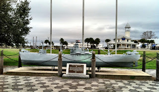
Brunswick WWII Memorial
Brunswick was a pleasant town - but almost completely deserted on Christmas Day.  Not a single business was open on the main street.  Two or three homeless individuals were the only people visible.  On a three mile run around the town I did find one taqueria and one laundromat open on the outskirts.  I took a picture of the WWII memorial to remember the town.  This was a strange and unforgettable Christmas Day.  Somehow I think Christmas is more fun when you can be with your family.


Shrimp is the big business in this area.  I was impressed with the forest of
Shrimpers booms in the air on our entrance into Brunswick GA
We would have continued to Jekyll Island on Christmas Day but Jekyll Creek is described as one of the shallowest sections of the ICW with some areas at only 2.5 feet.  Stopping at Brunswick allowed us to motor through Jekyll Creek at close to high water - about 7 feet of extra water to clear the bottom.  We had the luxury of following Brilliant Star the whole way.  Following another boat made finding marks and the channel much easier.  One section of the ICW in St. Andrews Sound is described as being in the Atlantic Ocean for a short way.  We found ourselves rolling hard as we negotiated our way through shoals in a relatively unprotected part of the Waterway.  A few hundred yards away we could see surf breaking in the shallows.  This like many other confusing areas of the ICW made me so happy we have a GPS plotter to show where we are.  The navigation would be much more nerve wracking without it.  I don't know how I found my way sailing through the waters of Maine with only a compass and depthfinder  as navigational instruments 28 years ago!

This large friendly colorful shrimp was the first to
greet us when we first set foot on a Florida Dock,

Finally today we crossed the border of Georgia into Florida!  Hooray!   We were excited.  We filled our fuel tanks and tied ourselves up to a mooring.  Tying up to a mooring was not an easy procedure.  The mooring has a very thick line with a stainless steel thimble.  (A thimble is a stainless steel eye inside a loop of line.)  It took me a while to figure out a way to tie it on so that it wasn't pulling hard on the stay that runs from the waterline at the bow to the bowsprit.  Once I did that I also had to move the anchor to keep it from rubbing against the pennant.  The anchor is now hooked on the bow pulpit rail.  We made it to shore by sunset.  Maryanne discovered a great restaurant off the main street.  We found it because of the colored lights and its sign: "Espana" a hundred yards or so down the side street.  Dinner was our celebration of finally reaching Florida.  Tomorrow we continue the excitement with laundry and food shopping.

Saturday, December 24, 2011

Black Beard Island

Today we motored from the Vernon River to Blackbeard Island, GA.  We thought we might go ashore to see the University of Georgia Marine Research Institute and its iconic Turkey fountain.  It was a little too windy to easily launch the dinghy and motor to  the ferry dock.  Instead we watched part of a movie tonight.  It is not beginning to feel a lot like Christmas here with warm weather and palm trees but there was a nice Christmas display on the dock where we anchored last night.  We have had some followers on this cruise -- a dolphin a few days ago -- and these guys stopped by to wish us a Merry Christmas:


And we would like to wish our friends and family and faithful blog followers 

A VERY MERRY CHRISTMAS!
and a
Happy Hannukah

Friday, December 23, 2011

South of Savannah

We made our way down the Savannah River in light  rain and continued warm temperatures.  (It went up to about 77 degrees yesterday.)  We could have stayed a night free at the River Bend Marina in Thunderbolt, GA 14 miles from our start in Savannah.  We pulled in to get fuel only to discover that they were closed for the holidays.  That turned out to be fine because I needed to pull our speedometer paddlewheel out of the bottom of the boat to free it up.  It was nice to be able to sit on someone's fuel dock with no pressure to move on.  Ordinarily I wouldn't be concerned about not getting a speed reading from the paddlewheel because I can get the speed of the boat from the GPS.  My problem was that the speed data is shared with the autopilot and the autopilot refuses to work without the speed data from the paddlewheel.  I should be able to reprogram the autopilot to work without the speed data but it was especially stubborn today - refusing to even accept reprogramming.

Taking the speedometer out of the bottom of the boat has some excitement and mess associated with it.  Pulling it out leaves a one inch hole in the hull.  A small geyser erupts from the hole while I fumble around trying to put a plug in it.  The in-rushing water makes it a little difficult to get that plug in just the right place as fast as I would like.  One of our carpets is a little wet from this exercise - but the paddlewheel is now freed up and I can continue steering the boat with the autopilot.  I prefer using the autopilot to steering by hand because the autopilot doesn't get distracted and forget to look where it's going.  I can't just let it do its own thing in the ICW but I can press +10 degrees or -10 degrees to adjust the course to the curves of the river.

Under a bridge and across the river we stopped at Bahia Bleu for $4.39/gallon diesel fuel.  It is important to fill up at this point because with the exception of one stop 5 miles down river there will be no more fuel available to us for 100 miles.  We expect to be well off the grid tomorrow deep in the swamps of Georgia with no cell coverage.

We ended our day early in the Vernon River.  We didn't realize until we talked with Chad (cruisingsabbatical.com) that we are anchored in exactly the same place he stopped when he was single handing 2 years ago.  We looked at his blog and discovered that the same shrimp boat that he took a picture of is still anchored out in the same area it was when he came through.  How do we know it's the same?  Dammit we know.  That is the boat's name: Dammit.  How many shrimpers could have that same name and be anchored in the same spot?


Dammit has been here a long time and seems to be listing
badly to port.
It is very pretty here with marshes on one side and wealthy large homes on the other.  No wind tonight but plenty of current.  We used the change in current to test my newest iPhone app: "DragQueen."  No, it didn't help me dress up in Maryanne's clothes.  DragQueen is an app that tells you when your anchor is dragging.  When the current changed on the river we moved far enough to set off the siren alarm on the DragQueen app.  It's great to know it works.  Now when we have high winds in an anchorage that is not in a river I can sleep soundly until the alarm goes off.

Sorry, no time to upload pix tonight.  We'll add them next time around.

Thursday, December 22, 2011

Goodbye Beaufort, SC. Hello Savannah, GA!

We spent way too little time in Beaufort - just a long walk to the Piggly Wiggly and back to the boat.  We understand that the historic homes are lovely – something for us to look forward to on our return trip.  We set up an ambitious 48 mile run for Wednesday from Beaufort to Savannah.  The Guides had the usual warnings about shoaling in some of the cuts between rivers – some confirmed by the Army Corps of Engineers.  The area they confirmed at 6 feet on one cut turned out to be no less than 24 feet.  We have another shallow area to traverse when we leave Savannah.  This time we may take the warnings seriously because we are told that stimulus money never found its way to dredging in Georgia.
We were expecting heavy ship traffic on the Savannah river but didn’t see a single vessel underway from the ICW to the City Dock.  The City Dock is in an exceptionally convenient area – right in the downtown historical district.  

After we arrived we saw ships that took our breath away.  They were longer than 2 city blocks and seemed to obscure the sky.  You feel as though you could almost touch them.  We've never seen so many floating behemoths.  The following video was made from our 4th floor restaurant perch - forgive the background conversation - ordering of food - but do watch to see how long it takes for this thing to pass by our window!  Then imagine being at water-level on our little 40 footer watching this thing pass next to and above us.


This is what is across the street from our boat


I called Chad (crusingsabbatial.com) to see if the ship traffic was a big problem at the dock.  I was afraid that the wakes from the big ships would have me rolling hard against the dock.  Ironically, the big 1000 foot plus ships have virtually no bow wave and hardly a ripple behind them.  They come up and down the river as slowly as they can.  It is the smaller craft – usually tugboats that set us rolling from side to side.
Our boat is barely visible through
the trees from Vic's Restaurant.

We had dinner at Vics on the 4th floor of a historic building overlooking the river.  The food was excellent – the price moderate.  The city side of the restaurant was at street level.  Behind our table was a Civil war era map that was uncovered during renovation of the building.  Down the street obscured by a few trees we could keep watch on Symphony at the dock.


The Westin Resort across the river from us.
Red and green lights on the towers for Christmas.


Symphony's last night on the City Dock

Tuesday, December 20, 2011

Beaufort, SC


We were a little on edge this morning because activecaptain.com and other sources indicated that some of the cuts we had to take between rivers today would not have enough water for us at low tide.  We were leaving on a falling tide and would hit the most difficult cuts at just about dead low.  We were on the Coosaw and Ashepoo rivers today.  One of the cuts - the Ashepoo Coosaw cut showed 3.6 feet on our depthfinder near the end of the cut.  Obviously our depthfinder needs to be calibrated but I'm so used to it that I'm afraid to change it.  It is nice to know that when it says 3.6 feet that we have enough water for our 5 foot draft.  Without our GPS we would never find our way through the labyrinth of waterways that brought us to Beaufort today.  The GPS was especially helpful in helping us navigate through narrow channels in mile wide rivers that had numerous shoals.  It is strange to be on a wide river and realize that right next to you in the middle of the river is a 2 foot deep spot.

We took a long walk into a local grocery store.  How could they be out of ricotta cheese?  Lasagne will not happen soon.
This was my day for trees. We loved the long soft hanging
moss on the old twisted oaks on the waterfront in Beaufort.
Maryanne in front of some expensive waterfront real estate.
Notice the length of the hanging moss on the tree behind her!


This barbershop quartet sang some Christmas carols for us
outside a local salon.  It reminded me that I need a haircut.
This tree caught my attention in one of the cuts.
You can tell the tide is very low.


Days end at the dock in Beaufort, SC
(We got lazy - we have to anchor out next time!)

Monday, December 19, 2011

Goodbye Charleston

Finally we tore ourselves away from Charleston.  We did our utmost to stimulate the economy there including the purchase of a new mainsail.  We told the sail maker that we did not want to hear that the reason our inmast roller furling mainsail was getting stuck in the mast was because it was blown or stretched out.  He ignored our instructions and told us that because it was stretched out into 3 dimensions it was not going to roll up into a 2 dimensional space.  That's techno-speak for "you are screwed."  Four weeks from now we are to give him instructions as to where to ship the sail.  Meanwhile we will be very careful with furling and unfurling our old mainsail.  It will be a pleasure to have a mainsail that furls and unfurls effortlessly.

Hard to believe this guy could fit through the narrow
passages of the ICW that we went through today.
During our 5 hours of motoring we did not encounter any other sailboats.  We did encounter one large tug and barge that left us little room in the channel.

Despite the many cautions we read in the Waterway Guide about shoaling and/or rocks on the sides of the channel we had no serious problems.  Without the GPS to guide us it would be hard to pick our way through all the different connecting cuts, creeks, and rivers that make up the ICW.

We ended our day anchoring in the South Edisto River.  It's pretty here - marsh on one side - trees on the other.  It is perfectly still and quiet this evening - no wind - no waves - and just a little bit of current to hold us in position behind our anchor.  Tomorrow
we head for Beaufort, SC.
Another day ends, anchored on the ICW on the South Edisto River in South Carolina.
(And as short as our day is the sun sets here 52 minutes later than in Glen Cove, NY.)