
Sunday, November 1, 2015
Restarting the Blog
After a disastrous unsuccessful attempt at a Gulf Stream crossing 2 years ago we stopped blogging. More about that later. Symphony is on the hard after 2 additional summer cruising seasons. Here she is in Mattituck this past September. We always feel a little uncomfortable entering the creek at low tide but our 5' draft has never touched the bottom. As you can see this is a nice anchorage despite the limited space. Restaurants, movies and grocery stores are within walking distance. This is a great area to bike, run and swim (depending on the wind and tide.)


Monday, December 16, 2013
On the fast track South from Chesapeake City
My crew and I had hoped to make it from Staten Island to Norfolk in a single 2 night run but the forecast of heavy seas on the ocean caused us to run up Delaware Bay to the C&D canal instead. To make up time we decided to sail the full length of Chesapeake from Chesapeake City overnight to Norfolk.
For once on our trip we had a favorable wind for our sail down the Chesapeake. Before the sun set in the West the moon was visible in the East.

After a sumptuous feast of Maryanne's chicken marbella we set up our night watches. We had enough ship traffic to keep us busy on our watches while the autopilot did the heavy lifting.
Gary reported that to keep himself from being bored on his 3-6 a.m. watch, he made up imaginary ships to watch and avoid. I guess he had a little trouble occasionally distinguishing between the shore lights and the ships. I was happy not to know about his imaginary ship activity before I went to sleep!
While we sailed most of the day, most of the night was spent motoring to Virginia.
The good news from the city marina in downtown Norfolk was that they had plenty of room and there was a wine festival going on. The bad news is that they charged $3.00 per foot ($120.00/night) and that they had a 2 night minimum. I decided that Hampton, VA would be a better choice. We stayed at the municipal marina and returned to one of my favorite little restaurants: "The Conch & Bucket." The name sounds like the Bahamas - the food reminds me of New Orleans. I ordered the Jambalaya.
 |
| View over our bimini on the Chesapeake |
For once on our trip we had a favorable wind for our sail down the Chesapeake. Before the sun set in the West the moon was visible in the East.

After a sumptuous feast of Maryanne's chicken marbella we set up our night watches. We had enough ship traffic to keep us busy on our watches while the autopilot did the heavy lifting.
Gary reported that to keep himself from being bored on his 3-6 a.m. watch, he made up imaginary ships to watch and avoid. I guess he had a little trouble occasionally distinguishing between the shore lights and the ships. I was happy not to know about his imaginary ship activity before I went to sleep!
While we sailed most of the day, most of the night was spent motoring to Virginia.
The good news from the city marina in downtown Norfolk was that they had plenty of room and there was a wine festival going on. The bad news is that they charged $3.00 per foot ($120.00/night) and that they had a 2 night minimum. I decided that Hampton, VA would be a better choice. We stayed at the municipal marina and returned to one of my favorite little restaurants: "The Conch & Bucket." The name sounds like the Bahamas - the food reminds me of New Orleans. I ordered the Jambalaya.
 |
| Symphony's Berth in Hampton, VA NY-VA in 3 hops. |
Wednesday, December 11, 2013
Great Kills to Chesapeake City (overnight)
We left Great Kills at 9 am and within an hour or so we began rocking and rolling. The high winds of the last several days left some uncomfortable 4 foot ocean waves hitting us on the beam. We put the main up but it did little to cut down on the uncomfortable side to side roll. Gary who says he always gets sea sick the first day out proved to us that he was telling the truth. Despite the Dramamine dosing he was hurting. I covered him up with some blankets in the cockpit while he slept and periodically hung his head over the side.
Our fearless autopilot steered the boat well. The bright animated lights on buildings in Atlantic City illuminated our way for over 20 miles down the NJ coast. We split up watches with John on from 9-12, I had the 12-3, and Gary had the 3-6 am watch. Gary finally had recovered in time for dinner.
By 1:30 a.m. we were ready to round Cape May, the southernmost part of NJ. I had a dilemma. A cruiser had given me 3 waypoints that would take us zig-zagging through potentially treacherous shallows close to Cape May. The advantage of following the waypoints is that they would save us the 2 hours it would take us to go out to the main ship channel. The disadvantage is that it would take us very close to shore and I wasn't sure that Superstorm Sandy hadn't changed the depths. Two years ago when I was sailing back to LI white water was swirling past the shallows. The white water was unnerving.
Studying the charts I found a compromise. There was an old channel (unmarked) slightly further outside my original route that didn't take me so close to shore. It would take a little extra time but not 2 hours - and - it wouldn't scare me to death in the dark early hours of the morning. I found the channel and although I still had to pass fairly close to some 2 and 4 foot spots I felt a little more comfortable further away from the shore.
I compared the depths on the depthfinder with what I saw on the chart. I was getting some big differences and not what I expected. Where the water was supposed to be 9 feet deep I was getting readings of 21 feet. That's OK but it had me wondering if I was where I thought I was. All these calculations are running constantly through my head at 2 o'clock in the morning - a time when I'm afraid I might not be at my peak decision-making best. The dark, the tiredness, and the repetitious bright loom of the Cape May light house in my eyes added to an air of spookiness. Sometimes it's a little nerve wracking to be on watch at night. You have to figure everything for yourself - and as captain you are supposed to be confident - your doubts are your own - not to be shared with the sleeping crew. I felt pretty good about my piloting skills and no one had to know that I was checking and double checking myself - but I was relieved once we got past the shallows into Delaware Bay!
Gary took over and I was able to get a good 5 or so hours of sleep. When I awoke John found that he was having a problem with our chartplotter and asked me to take a look at it. It did look a little strange - and it took me a few seconds after seeing the nuclear plant on the wrong side of the chart to realize that somehow John had turned us around and was taking us back to NY! We straightened that out and entered the C&D Canal within an hour.
After a stop at the Summit Marina on the north side of the canal to fuel up we found ourselves looking for a free berth on the public dock in Chesapeake City by 1 p.m. We had called ahead to see if there was any room. We were assured that there was. Wrong! The spot that would have been ours had a Tom Sawyer-like raft in it. Made of logs lashed together it had a tent on top of it - and on the tent was a live chicken. A young woman dashed off the raft every few minutes to grab a cat that seemed to need some serious shore leave. The gentleman who shared the raft later explained that he had done this voyage before and that it was being filmed for a possible reality TV show. Bizarre! There was also a dog and who knows what other animals shared the raft. After 2 days and 32 hours of motoring we anchored in Chesapeake City and went ashore for some lunch.
 |
| A couple of the cute little houses in Chesapeake City with one of the bridges that spans the C&D Canal |
Monday, December 2, 2013
Good bye NYC
Our first day provided some great views of NY
 |
| Lower Manhattan with the Freedom Tower on the left - Staten Island Ferry Terminals far right. |
 |
| The Verrazano Bridge and Long Island |
The wave off the bow in the picture below was a sign of things to come when we left Staten Island the next day.
 |
Monday, November 25, 2013
Bahama Bound II - The Fast Track
OK, we enjoyed the first cruise to the Bahamas,
now we want to do it again without the anxiety of the unknown ahead of us! Here it is we are -
BAHAMA BOUND AGAIN
Day 1
 |
| THERE IS NOTHING LIKE CRUISING DOWN THE EAST RIVER. Here's Gary fresh from California enjoying the East Coast scenery. |
As a compromise - Maryanne and I decided that I would put together a crew and deliver the boat to Florida in November while she continued teaching in Manhattan and Bay Shore. We would leave the boat there until we rejoined it in January when Maryanne will reluctantly retire. Retirement isn't easy when you truly love your job.
I invited Gary, my cousin's husband, and John, a biking buddy, to help me get "Symphony" south as fast as we could. I wanted to give Gary time to acclimate to NY but an all too brief weather window required a quick departure from Glen Cove less than 12 hours after he arrived. Brewer's Glen Cove was helpful - finishing up some last minute jobs for us before we departed.
New York Harbor - a Light Traffic Day on my ChartPlotter
 |
| AIS signals abound on a light traffic day in NY Harbor. Each red line and arrow represent the speed and course of a boat. The boats are represented by the triangles while the length of the red lines shows the relative speed of the vessel. My boat is the red boat symbol near the center of the bottom of the screen. |
AIS or Automatic Identification System identifies boats, their course, speed, time of closest approach, distance of closest approach, their names, sizes, and destinations. It makes it much easier to hail a vessel on VHF. If you want to discuss your course with another boat that has AIS you don't have to hail "the boat off my port bow." You can call him by name. While AIS transponders are required on commercial vessels over 65 feet it's easy to ignore big fishing boats or other smaller boats that may not have AIS. For that reason you have to constantly be scanning the horizon ahead, around, and behind you in a place like NY Harbor. This trip wasn't bad but you can see from the chartplotter that you better stay alert!
Monday, June 24, 2013
Snow!
The nor'easter following Sandy provided us with an experience we had never had before: boating in the snow. When power was restored to our home it was too treacherous to leave the boat until I shoveled the docks. The Espar heater kept us comfortable in the boat until we could return to civilization. So far our Caliber has worked very well for us. We plan to take the boat south again for the winter of 2013/14.
 |
| A week after superstorm Sandy we had a Nor'easter that delivered a little surprise: SNOW |
 |
| This was the view we woke up . |
 |
| The visibility forward from the cockpit was compromised. |
Wednesday, November 7, 2012
Super Storm Sandy
We were a little annoyed that although we had Symphony ready to be hauled Wednesday before the storm she was never hauled. We put extra lines on her in preparation for the storm with its projected 12 foot tidal surge. The surge had the potential to lift the floating docks right over the pilings. On Tuesday after the storm we approached the docks with more than a little trepidation. Symphony was unscathed as were all the other boats in the marina. (Brewer's Glen Cove). Although we had no power at home we had our batteries, solar power, and engine on the boat to generate power. Best of all, we have an Espar diesel heater aboard, installed thanks to the ingenuity of Jay Lesynski of Merri-Mar Yacht Basin in Newburyport, MA.
We moved aboard Symphony in the marina. After a few days of cloudy weather and about 3 hours of engine time the Marina's electric service was restored. We plugged in and have been here for 10 days. We've used about 12 gallons of diesel fuel.
Our home is frigid but our boat is cozy. Having lived aboard for 9 months sailing to and from the Bahamas 10 days isn't bad (but it is BETTER IN THE BAHAMAS!). Unfortunately, tonight we are experiencing a Nor'easter with thick snowfall and 35kt winds. The docks are too treacherous to walk on. We are constantly being startled by loud bangs on the deck. We have figured that these sounds are caused by falling pieces of ice. It is so strange to look out the portholes to see snow swirling in the lights and collecting on the deck. This is a completely new boating experience for us.
The major discomfort right now is caused by all the condensation on the hatches. When you least expect it you get a nice cold drip on your head or down your neck. The temperature in the main cabin is about 66 degrees - a little colder in our pullman berth forward - and a whole lot colder in the forward head where you have to be highly motivated to take a shower. The hot water quickly warms the shower stall so it really is bearable.
Super Storm Sandy was truly a super storm. The effects have been long lasting. Our biggest problem right now is getting gasoline. The gas stations all have power but no deliveries. People are waiting on lines outside gas stations overnight hoping that there will be deliveries the next day.
We were a little annoyed that although we had Symphony ready to be hauled Wednesday before the storm she was never hauled. We put extra lines on her in preparation for the storm with its projected 12 foot tidal surge. The surge had the potential to lift the floating docks right over the pilings. On Tuesday after the storm we approached the docks with more than a little trepidation. Symphony was unscathed as were all the other boats in the marina. (Brewer's Glen Cove). Although we had no power at home we had our batteries, solar power, and engine on the boat to generate power. Best of all, we have an Espar diesel heater aboard, installed thanks to the ingenuity of Jay Lesynski of Merri-Mar Yacht Basin in Newburyport, MA.
We moved aboard Symphony in the marina. After a few days of cloudy weather and about 3 hours of engine time the Marina's electric service was restored. We plugged in and have been here for 10 days. We've used about 12 gallons of diesel fuel.
Our home is frigid but our boat is cozy. Having lived aboard for 9 months sailing to and from the Bahamas 10 days isn't bad (but it is BETTER IN THE BAHAMAS!). Unfortunately, tonight we are experiencing a Nor'easter with thick snowfall and 35kt winds. The docks are too treacherous to walk on. We are constantly being startled by loud bangs on the deck. We have figured that these sounds are caused by falling pieces of ice. It is so strange to look out the portholes to see snow swirling in the lights and collecting on the deck. This is a completely new boating experience for us.
The major discomfort right now is caused by all the condensation on the hatches. When you least expect it you get a nice cold drip on your head or down your neck. The temperature in the main cabin is about 66 degrees - a little colder in our pullman berth forward - and a whole lot colder in the forward head where you have to be highly motivated to take a shower. The hot water quickly warms the shower stall so it really is bearable.
 |
| This gives you an idea about how difficult it was to get around after the Storm. Hard to see how electric service can be restored anytime soon. We have utility crews from Nova Scotia, Alabama, and Massachusetts. |
Monday, July 23, 2012
We made our way up to Deltaville from Hampton, VA. We fueled up and went for a quick walk through the boat yard identifying the boats on the hard that we had seen in the Bahamas or en route from the Bahamas. The next day we motored up to the Solomons and stayed at one of our favorite guest docks. The guest dock is close to Safina, another Caliber 40 owned by Dennis and Carolyn Chandler. Dennis and Carolyn invited us to dock there and join them for a sumptuous dinner on their screened in porch overlooking the water. We may be slightly prejudiced but all the Caliber owners we have met so far have been a pleasure to spend time with. It was fun comparing our sailing adventures in the Bahamas. We saw them too briefly in Georgetown. We also talked some potty talk - Vacuflush that is. We all love the Vacuflush when it's working but Carolyn has a much better working knowledge of hers - having had multiple experiences assembling and disassembling Safina's Vacuflush. The Vacuflush eliminates the need to manually pump water in and out of the boat's toilet. It has a vacuum tank that sucks the contents of the toilet out with a sometimes startling implosion and then electrically pumps out the tank re-establishing the vaccum for the next flush. The Vacuflush uses a small amount of fresh water instead of the odor laden saltwater that most marine toilets use. But enough potty talk. The Chesapeake is a wonderful cruising ground.

 |
| A typical Chesapeake Bay lighthouse - moved and preserved in the Solomons |

Wednesday, July 18, 2012
Saturday, June 16, 2012
Norfolk-Hampton VA
This morning we sailed past the little cove that we were warned against and found that it was empty. Next time we'll consider staying there. We tucked in behind a tug who got us through a restricted bridge a few minutes early only to get stuck at a RR bridge for 20 minutes. We heard a ferry captain make a comment about all the sailboats in the "Southern Branch." One tug skipper remarked that "It makes me feel so safe when those sailboats run into each other." It took us a little while to figure out what he was talking about but after passing a bend in the river we saw what looked like hundreds of sailboats wandering around in all different directions across the river.
Picking our way through them was a real challenge. We were under power and they were all sailing - so every last one of them had the right of way over us. We managed to get by most of them but as we cruised along the leeward side of the channel a cannon went off. We found ourselves at the start of one of the divisions. I wish my timing was as good in any of the races I've entered. We crossed the line just as the cannon sounded - a perfect start!
Everyone in the Norfolk area must own a sailboat. I don't think I've seen so many sailboats in one place since Block Island Race Week! The wind was gusting to about 25 knots so boats were moving fast and rounding up in the gusts - but what a beautiful scene.
 |
| We ended up following this little Hinckley yawl for awhile. Pretty boat but over-canvassed as were most of the boats in this race. |
Maybe tomorrow we will be able to head into the wind to Deltaville, VA.
Friday, June 15, 2012
We're Baaack!
Keeping up a blog is difficult - especially when you are pushing as hard as we are to get back to NY.
We have covered over 1000 miles in about 25 days not counting the time we took to fly to NY, Tampa, and finally to Wilmington, NC. It's also hard to be quite as excited about heading away from the Bahamas as it is to be headed toward them for the first time. We are pretty excited about the progress we have been making. Tomorrow looks to be a little rough for much of a passage so we'll look for a short run in the Norfolk area.
We have covered over 1000 miles in about 25 days not counting the time we took to fly to NY, Tampa, and finally to Wilmington, NC. It's also hard to be quite as excited about heading away from the Bahamas as it is to be headed toward them for the first time. We are pretty excited about the progress we have been making. Tomorrow looks to be a little rough for much of a passage so we'll look for a short run in the Norfolk area.
 |
| The Great Dismal Swamp Canal first built in 1805. Beautiful. |
We are anchored just north of the Deep Creek Lock on the
Great Dismal Swamp Canal. The
locktender, Robert, suggested that we might not like the little cove we were
originally headed for since it is a crazy Party Central on the weekends. He told us that we could anchor in
mid-channel just outside the lock. We
were the last boat to pass through the lock today so we’re good until tomorrow
morning’s opening at 8:30. It feels a
little strange to be anchored right in front of the lock.
 |
| Our 2 Calibers in front of Paul and Joyce's Home |
We spent yesterday at our friends' dock on the Pasquotank
River just south of the GDSC. Paul and
Joyce are generous hosts who give the term “Southern hospitality” new
meaning. Paul helped with a temporary
repair on our autopilot. The autopilot
broke free from its mount again in heavy seas on Albemarle Sound. We hope if we baby it, it will get us home to
NY where we can get a proper repair done on it.
Paul also showed me how to properly tighten the fan belt that has been
loosening up on my engine.
It was hard to take our eyes off the Pasquotank River and
our two Caliber 40’s from Paul and Joyce’s laundry, dining and living
rooms! The views of the river with the
big cypress trees are exquisite. Paul
also cooked us a sumptuous manicotti dinner – vegetarian style for Maryanne
topped off by rich chocolate brownies prepared by Joyce. Once again we had a wonderful time at the Wheeler's.
The Great Dismal Swamp Canal did not live up to it's original expectations because the water in it was not deep enough. That issue was partially solved with the addition of locks that lift boats 8 feet for a portion of the canal. Locking through is fun - watching the water boil in front of you as it comes in and the boat rises slowly 8 feet up the wall of the lock on the rising water.
 |
| At the bottom |
 |
| Going up |
 |
| Higher |
 |
| and higher |
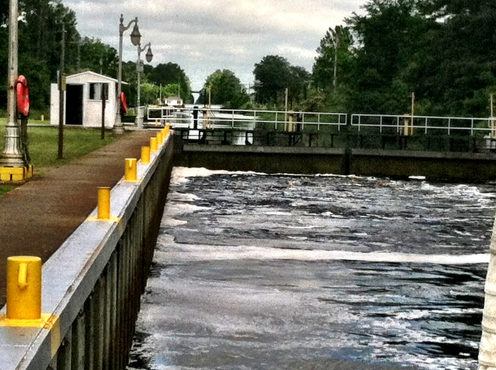 |
| Are we there yet? |
 |
| OK, We're finally 8 feet higher. Time to open the gates. |
Saturday, May 26, 2012
Northbound
After anchoring in Fort Pierce we didn't feel like dealing with customs right away. We waited to call an 800 number the next morning with our passport numbers, our location, and the personal info that they required. We were then directed to head to the nearest customs office within 24 hours. We were a little apprehensive about questions we might be asked about why we didn't call in immediately and exactly when we arrived etc., etc. As it turned out the customs official at the Fort Pierce International Airport asked only for our assigned number from the earlier phone call and for our passports. It took him all of 5 minutes to do the paperwork and to send us on our way.
With all the time it didn't take to clear customs we had enough time to motor up to Vero Beach. As we approached Vero we could see an impressive lightning show in the dark ominous clouds ahead of us. The radar showed them to be about 2 miles ahead. Luckily, we only saw a few drops of rain before we picked up our mooring in the Vero Municipal Marina mooring field. Melbourne airport (about 30 miles north) reported a record 1.8 inches of rain and 53 mph gusts in the squalls that just missed us.
We took advantage of Vero's free shuttle bus system to visit an Optical Store for a badly needed sunglass repair and to re-provision at Publix. The optical store opposite Publix was great. They spent 20 minutes working on the glasses and charged nothing. Maryanne did laundry while I cleared the fuel vent and added a strainer to our fresh water system.
We had heard that the City of Cocoa was worth a visit so we headed there - 8 hours away. It was worth the visit. We landed at a lovely waterfront park and after a very short walking tour had a wonderful breakfast at Ossarios.
We decided to do a shorter hop north to Titusville to give us time to do an oil and oil filter change. The fan belt is problematic since it can't be aligned perfectly so we find ourselves doing adjustments on it every couple of days. Our engine maintenance chores went smoothly.
We are trying to push north as fast as we can but after our 7+ hour motor with nice currents pushing us up to 8 knots we decided to take a lay day in St. Augustine. We did a tour today at Flagler College, formerly the Ponce de Leon Hotel.
The setting that the Flagler students have is unbelievable. Their college was built as a luxury hotel for the wealthy elite of the East Coast back in the late 1800's. In its heyday you had to have a written invitation from Mr. Flagler to be allowed to pay him the minimum 3 month stay in the hotel. If you did not have the proper social standing you had to look elsewhere.
With all the time it didn't take to clear customs we had enough time to motor up to Vero Beach. As we approached Vero we could see an impressive lightning show in the dark ominous clouds ahead of us. The radar showed them to be about 2 miles ahead. Luckily, we only saw a few drops of rain before we picked up our mooring in the Vero Municipal Marina mooring field. Melbourne airport (about 30 miles north) reported a record 1.8 inches of rain and 53 mph gusts in the squalls that just missed us.
 |
| The view from our mooring in Vero. Nice view, good laundry & showeres - easy access to town on the free shuttle. Delicious breakfast at TooJays Deli - maybe the best deli south of NYC. |
 |
| Here I am posing with some of the original people of the City of Cocoa. |
 |
| I loved the redneck wineglasses but not enough to buy one in Cocoa Beach. |
We had heard that the City of Cocoa was worth a visit so we headed there - 8 hours away. It was worth the visit. We landed at a lovely waterfront park and after a very short walking tour had a wonderful breakfast at Ossarios.
 |
| Ossario's threat to inattentive parents. Great breakfast - pastries to die for. |
We decided to do a shorter hop north to Titusville to give us time to do an oil and oil filter change. The fan belt is problematic since it can't be aligned perfectly so we find ourselves doing adjustments on it every couple of days. Our engine maintenance chores went smoothly.
We are trying to push north as fast as we can but after our 7+ hour motor with nice currents pushing us up to 8 knots we decided to take a lay day in St. Augustine. We did a tour today at Flagler College, formerly the Ponce de Leon Hotel.
The setting that the Flagler students have is unbelievable. Their college was built as a luxury hotel for the wealthy elite of the East Coast back in the late 1800's. In its heyday you had to have a written invitation from Mr. Flagler to be allowed to pay him the minimum 3 month stay in the hotel. If you did not have the proper social standing you had to look elsewhere.
 |
| Our guide at Flagler College. Her dining room is nothing like any other college I have seen - Tiffany windows, tiffany chairs, and elaborately painted ceilings. |
 |
| A detail of the dome at the entrance to Flagler. This woman is supposed to represent adventure. Do you see any resemblance to Maryanne? |
 |
| St. Augustine Lighthouse ca 1874 |
Wednesday, May 9, 2012
Good Bye Abacos
We landed in Marsh Harbor on Wednesday, May 2nd. We were a little worried about how our boat had fared in our 2 week absence. In the prior week 50 knot winds had buffeted the harbor. It was all good. The lines had not chafed through and the boat had not banged up against the dock.
After a quick trip to Maxwells, one of the 2 really good grocery stores in the Bahamas, we were sufficiently provisioned for our return trip to the states. Brown Tip, the bottom cleaning service hacked away at the bottom of our boat for an hour using a version of a compressed air hookah to breath underwater. As he worked it looked like chunks of turf were being expelled from our stern. Having the bottom cleaned at this point in our voyage was one of the smarter things that we have done. Our speed increased by about 1.25 knots after the cleaning.
We filled water tanks, water jugs, and lugged 4 five gallon containers of diesel down the dock and onto the boat the following day. Maryanne did her usual stowing magic, making everything disappear into places where they would not fall when we heeled to starboard or to port.
We had a little bit of a dilemma. Chris Parker, our weather guru, indicated that there would be a weather window open for a few days that would allow us to make a comfortable Gulf Stream crossing. I thought we would need a week just to reach the staging point for our crossing. If that were the case we would have to wait at Great Sale Cay for a week (where there is nothing to do) or wait at an expensive marina at West End on Grand Bahama for a week for the next weather window. Maryanne thought we could make it. She suggested a short hop Thursday afternoon to Great Guana Cay and then a stop at Green Turtle Cay about 20+ miles further. We thought we might get a last chance at good snorkeling on the way. We left Great Guana at 8:15 a.m. on Friday headed for Green Turtle Cay by way of the Whale Passage. The Whale Passage is a cut in and out of the Sea of Abaco that requires calm seas and in-flowing currents for safe passage. Our passage went smoothly. On our way to Green Turtle we decided to push further along get to our staging point. We decided on Foxtown.
I had asked Chris Parker by way of SSB radio what the difference would be if I sailed from Foxtown straight through the night to Fort Pierce, FL or if I went first to West End and sailed a day later. He reported that there would be little significant difference but that we would be bucking headwinds in the Gulf Stream if we waited until Sunday. As we made our way west I spotted Romanta Sea on the AIS ahead of us. I had a pleasant conversation with George, the skipper, who said he was headed for Great Sale, then to West End for fuel and ultimately to Savannah. Savannah was way more than we were ready to do!
Despite the fact that we might not make it into Great Sale with good light we decided to go for it. George assured us that the moon was closest to the earth tonight and that we would have no trouble finding our way in the light of the full moon. We made it by sunset - 11 hours. The next day Chris Parker told George that he needed to get north quickly to avoid some nasty weather. George who had offered to lead us through the tricky shallow Indian Channel set off directly for an overnight sail to Cape Canaveral. Before he left he let us know that a Beneteau 50, French Kiss, had been trying to contact us because they were headed to West End also. We spoke with Michael, the skipper of the Beneteau, and planned our joint departure for 8 to arrive at the Indian Channel on a rising tide.
The water was so still we could see the bottom clearly 12 feet below us. We could see dinner plate sized starfish on the bottom. Dolphins appeared at our bow. We could see them above and below the surface as they swam all around us and then back to French Kiss.
As it turned out we arrived at the Indian Channel with very little water to motor over. Despite the fact that it was a little past low tide the close pass of the full moon meant that the water was still lower than mean low water (the average low tide). French Kiss with her 6 foot draft followed slowly behind us as we radioed back the shallowest spots as we crossed them. We saw 4.1 feet on our poorly calibrated depth sounder but we know that we will hit bottom at 3.8 feet. 3.8 feet if it were properly calibrated should read 5 feet which is our draft. We had a good 3 1/2 inches to spare! After 9 hours of motoring we arrived at Old Bahama Bay Marina at West End on Grand Bahama Island.
We had some refueling problems with a faulty diesel pump and then fuel clogging our fuel vent but we managed to pour a couple of our containers of fuel into the tank and then filled the containers from a different pump. (after waiting for another boat to fill up with 225 gallons!) We docked without incident and went ashore for a celebration of our last night in the Bahamas at an outdoor restaurant on the beach. (While we were there we saw someone send their glass of wine back - it wasn't good enough! Who does that at a beach bar in the Bahams?!!! Usually you don't even get a glass - most wine is served in clear plastic cups! Yeesh!!)
At a little before 6 am in the dim light of pre-dawn I tried quietly backing our boat out of our berth in the marina. At first it went well - the stern wasn't kicking to port as usual and we were almost able to back into a berth behind us in order to make a left turn into the narrow channel between all the docks. Almost able. I couldn't get back far enough to make the left turn. I headed back for our berth and tried again. No good. This time I was getting too close to a small power boat on the wall to the right and behind our berth. Again I headed into our berth this time beginning to drift with wind too far to the right side of the berth. OK Maryanne had another idea. I tried using the left kicking reverse to back out to our left. Down the narrow channel between the rows of 16 boats each I backed the boat. It worked! I was able to turn the boat around at the end and turn to head the boat out the entrance into the Atlantic.
A fresh WSW breeze allowed us to sail close hauled and fast toward Fort Pierce - for 3 hours then the breeze clocked to the west and we had to motor into the wind and waves. The boat would go well for 10 seconds or so and then hit a wave - rise into it and then fall hard on the back side with a little bang. I hoped this wasn't going to be the west wind that Chris Parker had warned me about. I thought the wind was supposed to be 10 knots or less - this was more like 18. Eventually the wind settled down and the waves disappeared. We motored through flat seas checking the water temperature to see when we were in the Gulf Stream. We started out in 79 degree water but watched the temperature rise above 81. Suddenly it seemed a little warmer and the seas became completely flat. Our speed increased from 6 knots to 8.5. We were in the Stream. After 13 hours we put down our anchor in Fort Pierce harbor.
We felt accomplished! We had 3 days of travelling - 11 hours, 9 hours, and 13. If we had been driving a car from Glen Cove that many hours would get us to Santa Fe, NM! Sailboats are really slow!
We really enjoyed the Abacos. Fun places were a short easy sail from Marsh Harbour. We loved Hopetown with it's beautiful pastel colored homes and its well-protected harbor. Nippers, the bar scene, was something to behold above the beautiful Atlantic beach and the barrier reef. Our snorkeling off Fowl Cay in the Atlantic was excellent as was our swim over Mermaid Reef outside of Marsh Harbour. We enjoyed the cruisers we spent time with in Hopetown. We definitely want to come back for more. We need to explore Little Harbor with Pete's Pub and the foundry where sculpture is made. We also would like to spend some time at Green Turtle Cay. We definitely plan to return to the beautiful turquoise waters of the Abacos and the Exumas. The Berry Islands may also be on our agenda.
We landed in Marsh Harbor on Wednesday, May 2nd. We were a little worried about how our boat had fared in our 2 week absence. In the prior week 50 knot winds had buffeted the harbor. It was all good. The lines had not chafed through and the boat had not banged up against the dock.
After a quick trip to Maxwells, one of the 2 really good grocery stores in the Bahamas, we were sufficiently provisioned for our return trip to the states. Brown Tip, the bottom cleaning service hacked away at the bottom of our boat for an hour using a version of a compressed air hookah to breath underwater. As he worked it looked like chunks of turf were being expelled from our stern. Having the bottom cleaned at this point in our voyage was one of the smarter things that we have done. Our speed increased by about 1.25 knots after the cleaning.
We filled water tanks, water jugs, and lugged 4 five gallon containers of diesel down the dock and onto the boat the following day. Maryanne did her usual stowing magic, making everything disappear into places where they would not fall when we heeled to starboard or to port.
We had a little bit of a dilemma. Chris Parker, our weather guru, indicated that there would be a weather window open for a few days that would allow us to make a comfortable Gulf Stream crossing. I thought we would need a week just to reach the staging point for our crossing. If that were the case we would have to wait at Great Sale Cay for a week (where there is nothing to do) or wait at an expensive marina at West End on Grand Bahama for a week for the next weather window. Maryanne thought we could make it. She suggested a short hop Thursday afternoon to Great Guana Cay and then a stop at Green Turtle Cay about 20+ miles further. We thought we might get a last chance at good snorkeling on the way. We left Great Guana at 8:15 a.m. on Friday headed for Green Turtle Cay by way of the Whale Passage. The Whale Passage is a cut in and out of the Sea of Abaco that requires calm seas and in-flowing currents for safe passage. Our passage went smoothly. On our way to Green Turtle we decided to push further along get to our staging point. We decided on Foxtown.
I had asked Chris Parker by way of SSB radio what the difference would be if I sailed from Foxtown straight through the night to Fort Pierce, FL or if I went first to West End and sailed a day later. He reported that there would be little significant difference but that we would be bucking headwinds in the Gulf Stream if we waited until Sunday. As we made our way west I spotted Romanta Sea on the AIS ahead of us. I had a pleasant conversation with George, the skipper, who said he was headed for Great Sale, then to West End for fuel and ultimately to Savannah. Savannah was way more than we were ready to do!
 |
| Sunset at Great Sale Cay (Phew - we made it before dark!) |
Despite the fact that we might not make it into Great Sale with good light we decided to go for it. George assured us that the moon was closest to the earth tonight and that we would have no trouble finding our way in the light of the full moon. We made it by sunset - 11 hours. The next day Chris Parker told George that he needed to get north quickly to avoid some nasty weather. George who had offered to lead us through the tricky shallow Indian Channel set off directly for an overnight sail to Cape Canaveral. Before he left he let us know that a Beneteau 50, French Kiss, had been trying to contact us because they were headed to West End also. We spoke with Michael, the skipper of the Beneteau, and planned our joint departure for 8 to arrive at the Indian Channel on a rising tide.
 |
| At the center of the picture is a starfish 12 feet below the surface. This shot was taken as we motored at 6 knots over the Little Bahama Banks in a flat calm. The shadow of our mast is in the upper right corner. This is the last time this year that we will see this beautiful turquoise water! |
The water was so still we could see the bottom clearly 12 feet below us. We could see dinner plate sized starfish on the bottom. Dolphins appeared at our bow. We could see them above and below the surface as they swam all around us and then back to French Kiss.
As it turned out we arrived at the Indian Channel with very little water to motor over. Despite the fact that it was a little past low tide the close pass of the full moon meant that the water was still lower than mean low water (the average low tide). French Kiss with her 6 foot draft followed slowly behind us as we radioed back the shallowest spots as we crossed them. We saw 4.1 feet on our poorly calibrated depth sounder but we know that we will hit bottom at 3.8 feet. 3.8 feet if it were properly calibrated should read 5 feet which is our draft. We had a good 3 1/2 inches to spare! After 9 hours of motoring we arrived at Old Bahama Bay Marina at West End on Grand Bahama Island.
We had some refueling problems with a faulty diesel pump and then fuel clogging our fuel vent but we managed to pour a couple of our containers of fuel into the tank and then filled the containers from a different pump. (after waiting for another boat to fill up with 225 gallons!) We docked without incident and went ashore for a celebration of our last night in the Bahamas at an outdoor restaurant on the beach. (While we were there we saw someone send their glass of wine back - it wasn't good enough! Who does that at a beach bar in the Bahams?!!! Usually you don't even get a glass - most wine is served in clear plastic cups! Yeesh!!)
 |
| Sunrise as we leave West End with a trawler passing us. 83 miles to go. |
 |
| This guy startled me when he appeared just a few feet from my head 20 miles out to sea. I wasn't expecting anyone to get up and close and personal with me on my Gulf Stream Crossing! |
We felt accomplished! We had 3 days of travelling - 11 hours, 9 hours, and 13. If we had been driving a car from Glen Cove that many hours would get us to Santa Fe, NM! Sailboats are really slow!
We really enjoyed the Abacos. Fun places were a short easy sail from Marsh Harbour. We loved Hopetown with it's beautiful pastel colored homes and its well-protected harbor. Nippers, the bar scene, was something to behold above the beautiful Atlantic beach and the barrier reef. Our snorkeling off Fowl Cay in the Atlantic was excellent as was our swim over Mermaid Reef outside of Marsh Harbour. We enjoyed the cruisers we spent time with in Hopetown. We definitely want to come back for more. We need to explore Little Harbor with Pete's Pub and the foundry where sculpture is made. We also would like to spend some time at Green Turtle Cay. We definitely plan to return to the beautiful turquoise waters of the Abacos and the Exumas. The Berry Islands may also be on our agenda.
Tuesday, May 1, 2012
Heading back to Marsh Harbour
We're heading back to Marsh Harbour. Our spot messenger should start showing some movement within the next few days as we try to find a place to stage for our Gulf Stream crossing.
 |
| Our flight should bring us back over these islands near Marsh Harbour |
Monday, April 23, 2012
Assorted photos
 |
| I found these guys hanging out in Spanish Wells. A guy stopped his car and actually asked them how they were doing! |
 |
| Typical tidy homes of Spanish Wells on the waterfront |
Spanish Wells was clearly one of the more affluent of the Bahamian communities that we visited. The manager at the marina told us the community did well because it did not depend on tourist dollars.

We met this guy in Warderick Wells Land and Sea park. Although he did a nice job of cleaning up the crumbs in our cockpit he was a bit of a pest. He moved into our cabin. It took a little coaxing to get him to understand that we didn't want him there!
I thought I saw some blue-gray birds in the surf during our rough passage from Georgetown to Cave Cut but no - they were flying fish leaping out of the waves and gliding 60 feet or more.
 |
| Here we are on the pink sand beach. There is the slightest of pink hue in the wet sand. |
We made it to Harbor Island from Spanish Wells by way of the Devil's Backbone. We cheated. We took the high speed ferry. At points it seemed like we could reach out and touch the beach as we flew past. Some of our new friends hired a pilot to take their boats across the Backbone but the shoal depths made me wary even with a pilot. It would have been a quicker way to get north to Little Harbor in the Abacos but it wasn't for me. We rented a golf cart with Alan of "Unabated" and toured the island that is reputed to be the vacation destination of the rich and famous. The famed pink sand beach was a little less pink than I was expecting - but nice.
 |
| Here's the Bo Hengy II our 25 knot aluminum catamaran ferry to Harbor Island and back. It felt like sailing in fast forward mode! |
 |
| An example of the cuteness factor in Hopetown. This was on someone's front lawn complete with the Hopetown Lighthouse |
 |
| This path was lovely - no cars allowed - but the telephone cable didn't even clear my head! |
Hopetown was almost too cute but as you can see from my picture some of the infrastructure in the Bahamas is a little below the standards we have in the states.

If you have money you can do anything you like. We saw more than one big motor yacht with water slides like this. They usually also sport 4 or more jet-skis. Who decides to market water slides to these guys? http://freestylecruiser.com/
This is the latest in "must have" toys for the big boys. You can't buy them off the shelf - they have to be designed "to the exacting standards of your yacht."
We'll be ordering one of the first slides designed to be deployed from the spreaders of a sailboat.
 |
| The ubiquitous Bahamian lizard - chameleon? |
These little guys are everywhere all over the Bahamas. We were surprised to find one in our cockpit at anchor. We couldn't figure how he got there. I carefully unfurled a ziplock bag and tried to urge him to enter it. I'm a little squeamish so I didn't really want to handle him. He was not happy with the bag. He preferred to jump onto my hand. You'd be surprised how sticky his little feet are. I reflexively shook my hand but he wasn't leaving his perch. I also used some salty sailor language but he was unmoved. Finally with my hand in the bag I was able to rub him off and give him a ride to shore.
 |
| Alan from the Pearson 424, "Unabated" and I explored a ruins on Royal Island. It doesn't take long for tropical plants to take over the structures. |
Sunday, April 15, 2012
It's hard to keep up the blog with such poor internet access. We had a wonderful time with Chad & Nicole. We went snorkeling off the beach on a small island north of Great Guana Cay, also snorkeling on the Atlantic side of Fowl Cay, and finally swimming Mermaid Reef outside Marsh Harbor.
Chad and I went scuba diving with Above and Below off Fowl Cay. When Kay, the dive master began stroking a big friendly grouper I began smiling too widely causing my mask to flood slightly. Clearing the mask is simple but the fact that I had to do it made me laugh. Fortunately, I kept my regulator firmly in my mouth. The dive was so much fun - being able to do it with my son made it even more special.
Maryanne has become very comfortable with swimming and snorkeling. We had to swim a couple hundred yards from the beach to get to Mermaid Reef. We were able to swim together only a foot or so above the shallower parts of the reef. The yellow snappers came right up to us probably looking for a handout. Other fish and lobsters were more shy, hiding in little nooks under the reef. We didn't see any barracuda at Mermaid reef but there were a few at Fowl Cay. Fowl Cay was a bit of a challenge since we had to dinghy out to the reefs beyond the Cay. We also had to board the dinghy from the water. Maryanne and I have mastered the technique of going vertically underwater and then swimming and kicking hard straight up to scramble into the dinghy. The entry onto the dinghy isn't particularly graceful but it beats having to swim a mile and a half through a cut with strong currents. We are really enjoying the snorkeling in the Abacos.
We will be leaving the boat in the Abacos for a couple weeks while we return to NY for Maryanne's teaching. In NY I may be able to get some more pictures up on this blog.
 |
| After rigorous training Chad & Nicole show some aptitude for relaxation. The sailing life agrees with them. |
 |
| Homes on the Sea of Abaco outside Marsh Harbor near Mermaid Reef where we did some of our best snorkeling. |
Maryanne has become very comfortable with swimming and snorkeling. We had to swim a couple hundred yards from the beach to get to Mermaid Reef. We were able to swim together only a foot or so above the shallower parts of the reef. The yellow snappers came right up to us probably looking for a handout. Other fish and lobsters were more shy, hiding in little nooks under the reef. We didn't see any barracuda at Mermaid reef but there were a few at Fowl Cay. Fowl Cay was a bit of a challenge since we had to dinghy out to the reefs beyond the Cay. We also had to board the dinghy from the water. Maryanne and I have mastered the technique of going vertically underwater and then swimming and kicking hard straight up to scramble into the dinghy. The entry onto the dinghy isn't particularly graceful but it beats having to swim a mile and a half through a cut with strong currents. We are really enjoying the snorkeling in the Abacos.
We will be leaving the boat in the Abacos for a couple weeks while we return to NY for Maryanne's teaching. In NY I may be able to get some more pictures up on this blog.
Monday, April 9, 2012
Swimming in Marsh Harbor is not recommended.
Marsh Harbor is not a good place to swim - too many boats discharging effluent. I did take a little dip at the dock on Friday. The wind was pushing our boat too far away from the dock for Maryanne to get off the boat. The wind was strong - but so am I. I put my feet on one of the dock lines and pushed it down to get the boat in. Unfortunately, I wasn't wearing my tight rope walking shoes. My foot slipped and then instantly I found myself swimming in Marsh Harbor under the dock. It happened so fast I was swimming before I realized I was in the water! So...my BaTelCo wireless card is not waterproof. No more posts via BaTelCo.
The docks pose many problems. I landed at the dock at the Conch Inn on the downwind side with strong cross winds. As scary as the landing was - it went smoothly with help from the dock hands. The dockmaster when he returned later was unhappy with the berth that we had taken and told us that we would have to move. The wind was blowing 30 mph so I let him know that moving would be difficult in the extreme. He reluctantly agreed to make some adjustments while I stayed put. The next day he announced that we would have to switch berths. He left but gave us two dock hands to help out. The wind was again gusting over 30 knots sideways. When the boat backs the stern tends to walk to the left - in the same direction the wind was pushing us. To complicate matters, as we left the dock there were 2 pilings we had to thread 20 feet behind us. The situation was really close to impossible. To make everything really bad our stern line slipped off the cleat just as we were beginning to back out of the slip. Our stern swung 45 degrees off the dock toward another boat and a piling. A dock hand was able to throw the line back to me and pull me in for our next attempt to leave. We backed out smoothly thanks to an amazing performance by a cruiser who pushed our boat into the wind as we pulled away from the dock. With his dinghy acting as a side thruster or tug boat we were able to back in a straight line.
Our departure on Sunday was less smooth. As we backed out of our slip into strong wind another boat came off their dock blocking the path behind us. We pulled back into the slip and managed to barely hang on until the boat passed. Again we backed out of the slip but didn't get far enough into the wind to make our turn going forward. With the boat at right angles to the slip our stern began drifting into the bow anchor of a sailboat next to us while our bow pulpit looked like it would hit a piling in front of us. Chad was able to push hard against the bow pulpit of the boat with the threatening anchor while I tried to power the side of the bow to slide past the piling. Nicole pushed against the piling and somehow we managed to escape with only a splinter in Nicole's hand to show for it.
We have a new definition for docking:
Good docking is when no one is bleeding after the attempt.
Great docking is when you can still use the boat afterwards.
So far we are doing somewhere between great and good docking.
Friday, April 6, 2012
Hopetown, Abacos
 |
| Hopetown Lighthouse from our mooring. Kerosene flame lit by lighthouse keeper each night |
The first harbor we visited after successfully anchoring by Linyard Cay in the Sea of Abacos was Hopetown. Hopetown is a village of charming little homes of all different pastel shades overlooking the harbor. The entrance was challenging. We were warned not to attempt to enter until half tide or more. To enter the harbor you have to aim for a beach about a half mile away and then follow the beach to the left. Depths are about 6 feet with nearby patches of 4 feet. The harbor is one of the prettiest we have seen in the Bahamas.
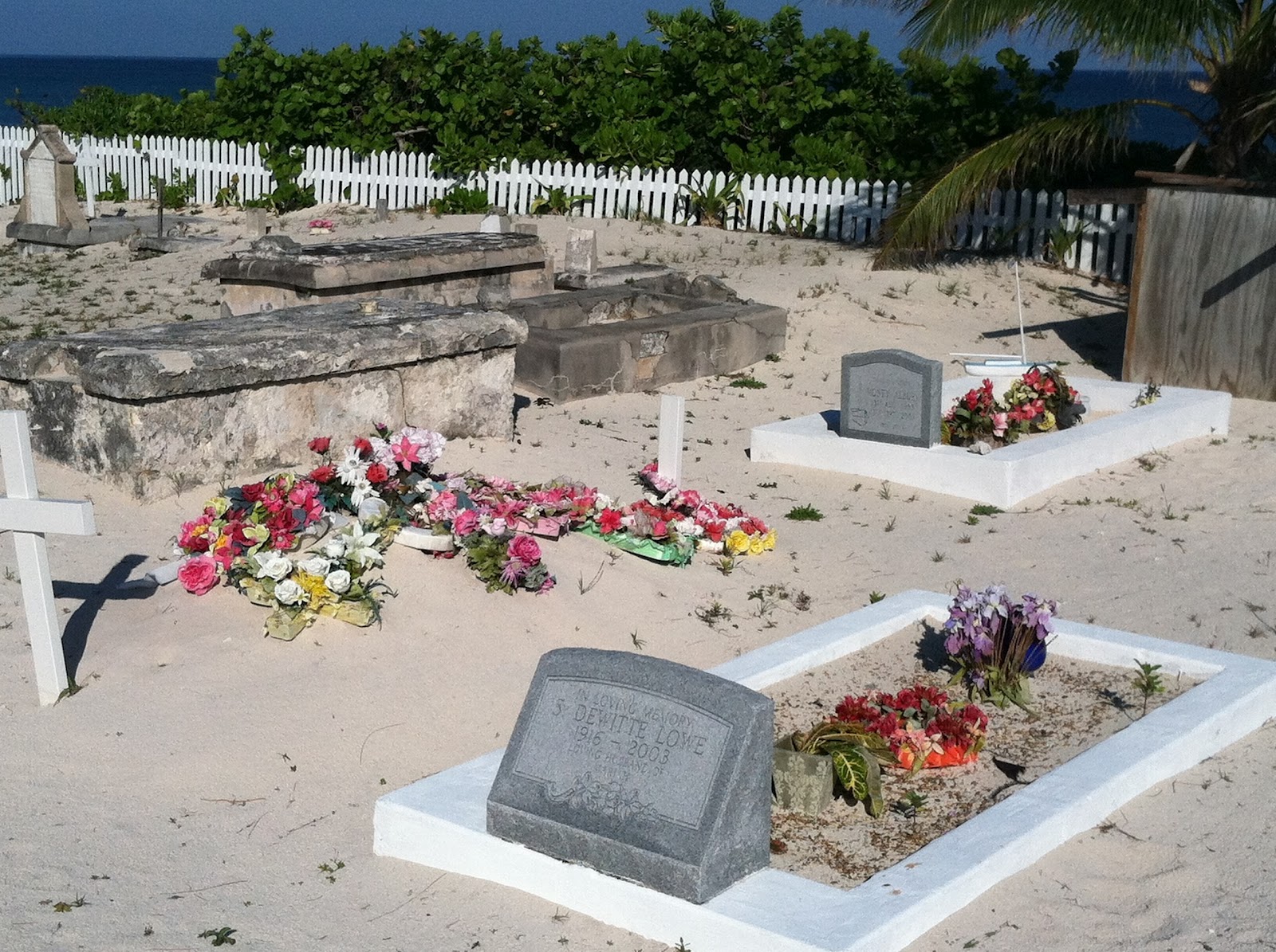 |
| Cemetery restoration project in Hopetown |
We took a walk up a street closed to vehicular traffic to an historic cemetery that is being restored. If it mattered to me where I was to be buried I would choose this cemetery. It has one of the best views I have ever seen.
We spent two days in Hopetown - met some really nice people - a couple aboard Katahdin - from Cape Elizabeth, Me. We also enjoyed spending time with Richard and Ward from Bagheera - a trawler that we met on our crossing to Rock Sound, Eleuthera. Ward gave us a ride to a restaurant in Spanish Wells on his rented Golf Cart.
 |
| The perfect way to end a dead end road. We saw this on our tandem bike ride through Hopetown. |
 |
| This is a fun building in Hopetown - a good place for ice cream but not for lunch |
We spent two days in Hopetown - met some really nice people - a couple aboard Katahdin - from Cape Elizabeth, Me. We also enjoyed spending time with Richard and Ward from Bagheera - a trawler that we met on our crossing to Rock Sound, Eleuthera. Ward gave us a ride to a restaurant in Spanish Wells on his rented Golf Cart.
 |
| A park on the Atlantic Ocean in Hopetown. |
 |
| Entrance to Hopetown |
In the next Blog: Mishap in Marsh Harbor
Subscribe to:
Posts (Atom)